Ausangate Travel 4 days combined the Mountain of seven colors is an adventure in the Andes, the snowy Ausangate is located in the Andes mountain range its maximum altitude is 6372 meters above sea level specifically in the Vilcanota mountain range in Cusco. On the way, we will appreciate the turquoise lagoons of Puccaqocha, llamas, alpacas in herds, and wild animals such as vizcachas, foxes, and vicuñas. In addition, we will connect to the 7 color mountain or also called rainbow mountain that makes this adventure unforgettable.
Our tour starts with the pick up from your hotel at 06:00 a.m. We will travel in a private minivan, for 2 hours and a half, on the route we can observe the Mapacho river that connects to the Urubamba river, beautiful valleys, and colorful villages like Urcos, Ocongate, Tinki until we arrive at the beginning of our hike called Upispama, where we will start with the hike to our first camp with cabins that is near the thermal baths of Upis. After lunch you have the option to walk to the lagoon of Ausangate, this hike takes about 2 hours approx. round trip and also if you like you can go to the hot springs, and at night you can appreciate the constellations that lie towards the majestic snow-capped Ausangate.
Pick up: 06:00 am from your hotel.
Hiking time: 3 hours approximately
Elevation of the beginning of the trail: 4,220 meters / 13,840 feet.
Highest elevation: 4,320 meters / 15,584 feet.
Difficulty Walking distance: 7 km / 4.5 miles
Moderate
Lodging: Camping
Altitude gain: 100 meters / 330 feet
Elevation of the camp: 4,320 meters / 14,100 feet
This morning we will wake you up at 06:00 a.m. with traditional coca tea or coffee delivered to your cabin then you will be served a delicious breakfast prepared by our chef. We will start walking up to the Arapa pass (4968 m). On the way we can meet the local people doing their daily activities such as grazing their alpacas or llamas as it is the main livelihood of the people, we will observe the imposing snow-capped Ausangate on the left side, our guide will explain every detail of the place. If we are lucky, we will be able to see condors, chinchillas, and vicuñas.
Then we will descend to our camp in Puca Cocha, where we will be surrounded by high mountains and hanging glaciers, and just above the lakes are located our shelters and dining room with a breathtaking view the dining room is built of stones, thatched roof to avoid altering the environment from there you can observe the avalanches, tents will be installed inside the shelters this time will keep your tents warm during the night our camp is located at 4100msnm.
Walking distance: 10 km / 6,21 miles
Hiking time: Approximately 5 hours
Elevation of trail: 4,300 meters / 14,100 feet
Highest elevation: 4,750 meters / 15,580 feet.
Difficulty: moderate/difficult.
Lodging: Camping
Altitude gain: 400 meters / 1,368 feet.
Camp Elevation: 4,500 meters / 14,760 feet
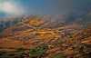
This day is the most difficult day of the Ausangate trek for 4 days. After breakfast, we will prepare to ascend to Puca Cocha pass (5051), surrounded by beautiful mountains with spectacular views of the snow-capped Ausangate, from the pass you will be able to see the red mountain of the Ananta Valley, an untouched landscape with colorful colors. You will be able to see the red mountain of the Ananta Valley, an intact landscape with vivid colors, in the course of your hike you will also find vizcachas and vicuña, after a rest, we will start with the descent, to then climb the second pass called Warmi Saya (15,090ft-4500m-14,000ft) from where, you can see a part of the incredible Rainbow Mountain or mountain of 7 colors in the distance, but you are not there yet! From this place, we head downhill to go around a small lagoon and continue walking until we reach our campsite which also has its own shelter where you will have lunch and spend the last night of our adventure in the mountains.
Walking distance: 10 km / 6,214 miles
Elevation of camp: 4,500 meters / 14,760 feet
Hiking time: Approximately 7 hours
Elevation of the trail: 4,500 meters / 14,760 feet
Highest elevation: 4,990 meters / 16,375 feet.
Difficulty: moderate/difficult.
Lodging: Camping in cabins.
Altitude gain: 800 meters / 2,368 feet.
Today is the day we will wake up very early 04:45 a. m, to be the first in the mountain of colors, our camp is located 45 minutes from the mountain of 7 colors to see the sunrise, we will take coffee and warm clothes because the cold is intense, after taking the best pictures we will descend to the red mountain or red valley is 30 minutes downhill after that we will go to the bus station where we will pick up our private transport to Ttio a small town where we will have lunch and return to Cusco and arrive at your hotel around 4 pm.
Walking distance: 1 km / 0,621 miles
Elevation of trail: 4,900 meters / 16,076 feet
Highest elevation: 5,050 meters / 16,568 feet.
Difficulty: easy
Altitude gain: 100 meters / 328 feet}
Hiking time: approximately 45 minutes
Drop off: 03:00 pm at your hotel

Do not hesitate to call us. We are a team of experts and we will be happy to talk to you.
 Consult an expert
 Chat
Chat